Chris Izworski / Lake Superior Circle Tour / Apostle Islands

THE WISCONSIN SHORE OF LAKE SUPERIOR

Apostle Islands Explorer

Here, the lake has spent centuries carving rooms into red sandstone. Lighthouses stand watch above the water. But the most important choice comes before the first island: how will you get there?

First visit? Start with a narrated cruise from Bayfield, the mainland at Meyers Beach, or the Madeline Island ferry. Sea kayaking and remote island trips demand extra planning.

Find your adventure ↓Compare eight islands ↓Inspect landings ↓Explore island maps ↓

21 islands in Apostle Islands National Lakeshore. Madeline Island is a separate, ferry-served island outside the National Lakeshore.

Devils Island reddish sandstone sea cave and lake water
Photo: DataThread · CC BY 4.0

Devils Island sandstone sea cave · archival photograph, not current conditions

PICK YOUR KIND OF DAY

Where do you want the lake to take you?

Choose the experience and time that fit. The cards and map narrow together, while every official source link remains available.

Experience

Showing all 9 experiences. These are planning options, not real-time availability.

Before a paddle

The UW Sea Caves Watch buoy may be offline seasonally. See NWS marine forecasts and NPS safety guidance, and talk to your outfitter. No online reading is launch clearance.

Before a boat trip

A cruise past an island is not an island landing. NPS-authorized services list available operators, but dates and stops require separate confirmation.

2026 access notice

Little Sand Bay construction restricts parking and may reroute launch access. Devils Island's marina remains closed during work. Recheck before travel.

THE ISLAND-BY-ISLAND FIELD DESK · 2026 VERIFIED SOURCES

Which island can you actually visit?

The archipelago is not one destination. Each island has different docks, trails, camping rules and transport. Here are eight access-evidenced islands to compare before you make plans.

Island names are not navigation waypoints. Documented dock names do not guarantee an open berth, safe landing, ticket, or transport. Last evidence review: October 27, 2026; recheck for 2027.

What do you want to do?

Showing 8 access-researched islands; this is not a list of open docks or live bookings.

01

Singing sands & island trails

Stockton Island

Public dock documented

Walk from Presque Isle through pine woods to Julian Bay, or continue deeper into the island where an old quarry and quieter shoreline await.

LANDING

Presque Isle east/west public docks; Quarry Bay public dock

HOW TO GET THERE

Operator lists a seasonal Stockton day-hiking shuttle and overnight camping shuttle; the published 2026 season has ended.

CAMPING

NPS designated campsites; accessible site 1 at Presque Isle and group A/B at Quarry Bay. Permits and transport required.

Explore 3 NPS-documented trails +
  • Julian Bay Trail · 0.4 miles — From the Presque Isle ranger station to Julian Bay beach.
  • Anderson Point Trail · 1.4 miles — Wooded route between Julian Bay and the dock.
  • Tombolo Trail · 2.8 miles — A lagoon outlet can require wading.

Verify before departing: A Presque Isle–Quarry Bay trail bridge was washed out; check current crossing conditions before choosing longer routes.

02

High overlooks & long walks

Oak Island

Public dock documented

Follow old beach ridges through hardwood forest to a view of islands and the Hole-in-the-Wall sea arch.

LANDING

Public west-side dock; sandspit landing is a separate small-craft decision

HOW TO GET THERE

Operator lists a seasonal overnight camping shuttle; it is not advertised as a regular same-day hiking shuttle.

CAMPING

Designated individual and group sites; check the exact campsite's dock or sandspit approach.

Explore 3 NPS-documented trails +
  • Loop Trail · 5.2 miles — Horseshoe hike rising over the lakeshore's highest island point.
  • Overlook Trail · 1.8 miles — Branch from the loop trail; overlook is 3.5 miles from dock.
  • Sandspit Trail · 1.5 miles — Beach walk toward campsites, stay on established trail or sand.

Verify before departing: An outbound ferry or shuttle ticket is not proof of a same-day return. Arrange pickup in advance.

03

Red sandstone lighthouse

Sand Island

Public dock documented

The path from East Bay leads toward an 1881 brownstone lighthouse and an old keeper's view of western Lake Superior.

LANDING

Public East Bay dock (no dock at Lighthouse Bay verified)

HOW TO GET THERE

No regular Sand Island landing shuttle verified. Arrange an authorized water taxi or suitable private boat and return.

CAMPING

Designated sites and group sites; NPS identifies accessible site 3 and group C by East Bay boardwalk. Permit required.

Explore 2 NPS-documented trails +
  • Lighthouse Trail · 2 miles — From East Bay dock to the lighthouse; wet boardwalks may be slippery.
  • Wellisch Cabin Trail · 0.6 miles — Old roadbed south past designated camping areas.

Verify before departing: West Bay Club is closed, southeastern private docks are not public, and NPS says campsite coordinates are being corrected.

04

Historic lighthouse grounds

Raspberry Island

Public dock documented

A white lighthouse, forest canopy and small beach invite a quieter historical stop.

LANDING

Public east and west docks by the light station

HOW TO GET THERE

Operator publishes a seasonal Raspberry Island lighthouse tour with island time; confirm the future season and on-site tour access.

CAMPING

No designated campsites listed; Raspberry is excluded from primitive camping zones. Treat it as a day visit.

Explore 2 NPS-documented trails +
  • West Bay Trail · 1 miles — From light station toward views of Sand Island.
  • Sandspit Trail · 0.75 miles — Old-growth forest route to the southeast beach.

Verify before departing: This is Wisconsin's Apostle Islands Raspberry Island, not Isle Royale's island with the same name.

05

Light stations & sandy spit

Michigan Island

Public dock documented

The light station and lagoon trail lead away from the open lake toward a remote island shoreline.

LANDING

Public dock at Michigan Island light station

HOW TO GET THERE

A Michigan Island lighthouse excursion is advertised; verify whether a specific departure actually lands and permits touring.

CAMPING

NPS lists designated Michigan Island campsite options. Book a permit and arrange round-trip transport separately.

Explore 2 NPS-documented trails +
  • Sandspit / Campsite Trail · 1 miles — From the light station to sandspit campsites.
  • Lagoon Trail · 0.5 miles — Trail appears to end at a bog before resuming farther on.

Verify before departing: The bog crossing is not a continuous surfaced trail; sightseeing on water does not guarantee an island landing.

06

Forest, camps & fishing history

Rocky Island

Public dock documented

Small stretches of shore and modest wooded trails offer a less crowded island experience.

LANDING

Public east-side dock

HOW TO GET THERE

No scheduled passenger shuttle confirmed; plan a water taxi or private vessel with a verified return.

CAMPING

Designated and group camping; permit required.

Explore 3 NPS-documented trails +
  • West Trail · 1 miles — Wooded trail across the island from the dock.
  • South Trail · 0.9 miles — Follows the island's eastern shoreline.
  • North Trail · 0.45 miles — Past campsite area north of the public dock.

Verify before departing: Private land north of Group Site A is not publicly accessible. Never use private docks as an access suggestion.

07

Quarry & farm remnants

Basswood Island

Public dock documented

A substantial loop through old farm ground and stone-working sites tells the history of the lake's industrial shores.

LANDING

Public west-side dock

HOW TO GET THERE

No regular passenger shuttle verified. Arrange licensed water transport or private boating and a return.

CAMPING

NPS campsite directory lists designated Basswood campsites; backcountry permit required.

Explore 1 NPS-documented trail +
  • Farm & Quarry Loop · 5.5 miles — NPS loop from dock through McCloud-Brigham farm site and the historic brownstone quarry.

Verify before departing: The quarry is historic industrial terrain; stay on maintained routes and do not enter unsafe structures.

08

Sea caves · dock closed

Devils Island

DOCK CLOSED

The outer island holds some of the most dramatic sandstone sea caves, but a visitor landing itinerary is not currently supportable.

LANDING

South dock and marina closed for 2026 rehabilitation; no arrival instructions offered

HOW TO GET THERE

Offshore viewing only when authorized operators and weather permit. Do not plan to land.

CAMPING

NPS ongoing alerts list Devils Island campsites closed; primitive camping not permitted.

Explore 1 NPS-documented trail +
  • Boathouse Trail · 1 miles — Historic trail exists in NPS inventory but the south landing is closed; not a visit recommendation.

Current access closure: Closed dock, boathouse and adjacent areas. A trail entry in NPS inventory does not reopen island access.

Side-by-side island comparison

Check up to two island cards. Compare public landing evidence, transport, hikes and camping without inventing a current opening.

Select two islands above to compare their access requirements.

Before you reserve a trip

As of the reviewed 2026 information, Stockton Island has a published seasonal day-hiking shuttle, while Oak Island has an overnight shuttle. Other islands may require a water taxi or private vessel. An NPS campsite permit and island transport are separate arrangements.

Group camping and designated campsite policies differ from primitive zones. No island dock is a guaranteed berth. Be particularly cautious with Lake Superior wind, wave reflection, cold water and shifting shorelines.

A FIELD GUIDE YOU CAN EXPLORE

Know the island before you land

Study the actual NPS island trail maps, then explore individual campsite locations where the Park Service publishes trustworthy reference coordinates. The trail lines on the original maps are not reconstructed or guessed. Choose the island, then choose an NPS-documented dock-to-trail relationship. The map highlights related campsite *references* but never invents a connecting trail line.

Trail maps are not marine navigation charts. The NPS campsite directory dates to February 9, 2026. These 42 reference points do not establish campsite availability, public landing access, safe water depth or a walkable route. Sand's campsite coordinates are being corrected by NPS and are excluded. The closed Devils Island south landing and anomalous campsite coordinate are excluded, too. NPS campsite directory ↗
Map tiles not available?

Use the NPS island maps, coordinates and source links provided below. No map is needed to read the trail descriptions.

Choose a documented island sequence

Selected campsite markers will be emphasized only where the NPS publishes reference coordinates. A highlighted site is not a plotted trail or a current reservation.

Showing NPS-listed campsite positions for Stockton Island. The map does not plot hiking routes.
Individual campsite reference Group site reference NPS-documented boardwalk access

Map tiles © OpenStreetMap contributors / CARTO when available. Campsite positions © National Park Service source directory, reviewed October 28, 2026. NPS maps ↗

OFFICIAL NPS ISLAND MAP

Stockton Island

Wiisaakodewan-minis

From the quiet sand of Julian Bay to an old brownstone quarry, Stockton asks you to choose which shoreline you want to meet.

Ranger's note: Three distinct public dock approaches in the NPS list. The Presque Isle–Quarry Bay trail connection has had a bridge washout; verify trail conditions before committing.

DOCK → TRAIL → CAMPSITE

Follow the evidence, not a guessed route

Choose a documented sequence to see how the NPS describes a particular dock, trail and campsite. These are planning steps, not navigational track lines or current travel approval.

NPS boardwalkPresque Isle: boardwalk to site 1Sites: 1

Documented relationship: NPS-documented accessible boardwalk

  1. 1

    Arrive only if the west Presque Isle public dock is usable and your transport is confirmed.

  2. 2

    Use the NPS-documented boardwalk from the west-side harbor dock to accessible campsite 1 and nearby facilities.

  3. 3

    Confirm site 1 permit separately; check the return crossing with your operator.

Before you rely on it: The campsite path is documented; the water approach, docking and reservation are not verified here.

NPS site-access descriptionPresque Isle: shoreline campgroundSites: 2, 3, 4, 5, 6, 7, 8, 10, 11, 12, 13, 15, 16, 17, 18, 19

Documented relationship: NPS campsite locations along Presque Isle Bay

  1. 1

    Arrive at Presque Isle only with a confirmed vessel and dock plan.

  2. 2

    NPS places campsites 2–19 along about three-quarters of a mile of Presque Isle Bay shoreline; site 2 is nearest the dock.

  3. 3

    Use the official campground map and signs to locate your assigned site; arrange return transport.

Before you rely on it: NPS does not name a continuous dock-to-site trail for every campsite. Erosion has removed direct beach access at many sites; no straight-line approach is shown.

NPS boardwalkQuarry Bay: accessible group camps A and BSites: A, B

Documented relationship: NPS-documented Quarry Bay boardwalk

  1. 1

    Verify your boat's approach and public Quarry Bay dock access.

  2. 2

    Follow the NPS boardwalk from the Quarry Bay dock to group campsite A or B.

  3. 3

    Confirm the specific group reservation, printed permit and return trip.

Before you rely on it: These are group sites, not individual campsite substitutes. The former inter-bay bridge washout means no unverified overland route between Quarry and Presque Isle.

NPS site-access descriptionQuarry Bay: individual site 20Sites: 20

Documented relationship: NPS describes site 20 as ¼ mile west of dock

  1. 1

    Check the public Quarry Bay dock and independent vessel return plan.

  2. 2

    NPS locates site 20 about one-quarter mile west of the dock, in trees behind the west end of the beach.

  3. 3

    Confirm the site permit and local wayfinding; no traced footpath has been inferred.

Before you rely on it: A published site location is not a mapped trail alignment. Do not substitute the nearby beach for guaranteed landing access.

NPS day trailJulian Bay beach walkNo campsite claimed

Documented relationship: Julian Bay Trail · 0.4 mile

  1. 1

    Arrive at the Presque Isle visitor area using authorized water transport.

  2. 2

    Walk the NPS Julian Bay Trail from the ranger station to the beach.

  3. 3

    Return to the dock on your confirmed transport schedule.

Before you rely on it: This is a day-hike relationship, not a campsite route. The 0.4-mile published trail length does not include transport or other walking.

Official National Park Service map of Stockton Island showing mapped trails, shoreline types and island landmarks

Original NPS map. Trail lines belong to this source map; our campsite dots are separate published reference coordinates. Enlarge NPS trail map ↗

Trails on the NPS map

  • Julian Bay Trail0.4 mi

    From Presque Isle ranger station to Julian Bay.

  • Anderson Point Trail1.4 mi

    Woodland path between the Presque Isle dock and Julian Bay.

  • Tombolo Trail2.8 mi

    Bog and beach; lagoon outlet may require wading.

  • Quarry Bay Trail3.6 mi

    From Presque Isle toward Quarry Bay; meadow route can be indistinct.

  • Quarry Trail1.5 mi

    From Quarry Bay toward the old brownstone quarry.

  • Trout Point Trail6.3 mi

    Unmaintained route through island interior; difficult route finding.

Read original NPS hiking descriptions ↗

Sites NPS publishes coordinates for 21

Select an individual site to locate the published reference position on the adjacent map. These coordinates do not establish an open campsite, correct access path or available reservation.

OFFICIAL NPS ISLAND MAP

Oak Island

Mitigominikaani-minis

This is the island of long trails: ancient beach ridges, sugar maples and overlooks high above Lake Superior.

Ranger's note: The NPS overlook is about 3.5 miles from the dock, not 1.8 miles from the dock. The published operator schedule was for overnight service; a same-day return must be arranged separately.

DOCK → TRAIL → CAMPSITE

Follow the evidence, not a guessed route

Choose a documented sequence to see how the NPS describes a particular dock, trail and campsite. These are planning steps, not navigational track lines or current travel approval.

NPS site-access descriptionOak: campsites nearest the west dockSites: 2, 3, B

Documented relationship: NPS-described west-dock approach

  1. 1

    Confirm transport to the NPS west public dock.

  2. 2

    NPS locates individual site 2 about 0.1 mile west, site 3 about 0.25 mile west and group B about 50 yards west of the dock.

  3. 3

    Locate your assigned campsite using the NPS map and check the permit and pickup.

Before you rely on it: These are NPS descriptive distances, not a drawn trail. Group B is a group-permit site.

NPS named trailOak: sandspit campsites 1 and ASites: 1, A

Documented relationship: Sandspit Trail · NPS describes 1.5 miles from dock

  1. 1

    Confirm west dock landing and an actual return boat.

  2. 2

    Follow the NPS Sandspit Trail toward the southern sandspit.

  3. 3

    Locate individual site 1 or group A on the designated sandspit area; use only established paths, boardwalks or beach.

Before you rely on it: Sandspit vegetation is fragile. Group site A requires a group reservation. Dock-to-sandspit distance comes from the NPS campsite description.

NPS named trailOak: Northwest Beach campsite 4Sites: 4

Documented relationship: Northwest Beach Trail via Loop Trail

  1. 1

    Confirm landing at the west dock and assess the longer backcountry day.

  2. 2

    Take the NPS Loop Trail to the Northwest Beach Trail junction, then follow that named trail toward campsite 4.

  3. 3

    Verify campsite allocation, daylight and the return route before leaving the dock area.

Before you rely on it: NPS trail and campsite pages give slightly different dock-to-site distances (about 2.8 and 3 miles). No exact total or route geometry is inferred.

NPS named trailOak: North Bay campsite 6Sites: 6

Documented relationship: North Bay Trail via Loop Trail

  1. 1

    Confirm west dock access and allow for a longer overland approach.

  2. 2

    Follow NPS Loop Trail connections to the North Bay Trail and campsite 6.

  3. 3

    Verify site-specific conditions and how you will leave the island.

Before you rely on it: NPS descriptions differ slightly on dock-to-site distance (about 3.7 and 4 miles). This guide does not resolve that into a false precise estimate.

NPS day trailOak: high overlook hikeNo campsite claimed

Documented relationship: Loop Trail to Overlook Trail

  1. 1

    Arrive at the west dock with a scheduled return plan.

  2. 2

    Follow the inland Loop Trail to the signed Overlook Trail junction.

  3. 3

    Enjoy the view and return by the documented trail network in time for your confirmed boat.

Before you rely on it: NPS describes the overlook roughly 3.5 miles from the dock. This is a trail outing, not a shortcut to a campsite.

Official National Park Service map of Oak Island showing mapped trails, shoreline types and island landmarks

Original NPS map. Trail lines belong to this source map; our campsite dots are separate published reference coordinates. Enlarge NPS trail map ↗

Trails on the NPS map

  • Loop Trail5.2 mi

    Horseshoe from the public dock through the central uplands.

  • Northwest Beach Trail1.6 mi

    Branch off the loop, reaching campsite 4 about 2.8 miles from dock.

  • Overlook Trail1.8 mi

    Spur from inland junction; overlook about 3.5 miles from dock.

  • North Bay Trail1.1 mi

    Ravine route to campsite 6, about 4 miles from dock.

  • Sandspit Trail1.5 mi

    Beach and sites 1/A. Stay on established trails and bare beach.

Read original NPS hiking descriptions ↗

Sites NPS publishes coordinates for 7

Select an individual site to locate the published reference position on the adjacent map. These coordinates do not establish an open campsite, correct access path or available reservation.

OFFICIAL NPS ISLAND MAP

Sand Island

Waabaabikaa-minis

Walk from East Bay toward a lighthouse above the lake, or take the old roadbed into the island's cabin history.

Ranger's note: NPS is updating Sand Island campsite coordinates. Their previously published latitude/longitude entries are deliberately NOT plotted here. Refer to its official campsite map, posted signs and current ranger guidance.

DOCK → TRAIL → CAMPSITE

Follow the evidence, not a guessed route

Choose a documented sequence to see how the NPS describes a particular dock, trail and campsite. These are planning steps, not navigational track lines or current travel approval.

NPS boardwalkSand: accessible site 3 and group CSites: 3, C

Documented relationship: NPS-documented East Bay dock boardwalk

  1. 1

    Check East Bay public dock access with your operator.

  2. 2

    Use the NPS boardwalk to accessible site 3 or group C (NPS lists them near the dock).

  3. 3

    Verify campsite permit and return transport independently.

Before you rely on it: NPS is correcting Sand Island campsite coordinates. These connections are documented in prose but no campsite pins are plotted.

NPS named trailSand: Wellisch Cabin Trail campsSites: 2, A, B

Documented relationship: Wellisch Cabin Trail · 0.6 mile

  1. 1

    Land only if the East Bay dock and transport are confirmed.

  2. 2

    Follow the Wellisch Cabin Trail south from East Bay dock, passing site 2 and group sites A and B.

  3. 3

    Find the assigned site from current NPS signs; arrange an independent return.

Before you rely on it: No Sand campsite coordinates are plotted while NPS corrects its published table. A/B require group camping permits.

NPS named trailSand: lighthouse approach and site 6Sites: 6

Documented relationship: Lighthouse Trail · NPS lists site 6 about 1 mile north

  1. 1

    Arrive at the NPS East Bay dock with confirmed transport.

  2. 2

    Take the Lighthouse Trail north; NPS locates site 6 on the east side about a mile from the dock.

  3. 3

    Use the official map and signs for the site, then confirm permit and return.

Before you rely on it: Site 6 has a separate toilet approach; NPS says there is no direct campsite-to-toilet path. Site coordinate withheld pending corrections.

NPS day trailSand: lighthouse day walkNo campsite claimed

Documented relationship: Lighthouse Trail · 2.0 miles

  1. 1

    Confirm East Bay dock access and return pickup.

  2. 2

    Take the NPS Lighthouse Trail north from the dock toward the lighthouse.

  3. 3

    Return using the original mapped trail, allowing for conditions and the actual boat schedule.

Before you rely on it: The boardwalk may be slippery when wet. This is not an endorsement of landing at Lighthouse Bay or reaching campsites 4/5.

Official National Park Service map of Sand Island showing mapped trails, shoreline types and island landmarks

Original NPS map. Trail lines belong to this source map; our campsite dots are separate published reference coordinates. Enlarge NPS trail map ↗

Trails on the NPS map

  • Lighthouse Trail2.0 mi

    From East Bay dock north to the lighthouse; boardwalk can be slippery.

  • Wellisch Cabin Trail0.6 mi

    Old roadbed south past sites 2, A and B. No maintained path to Lighthouse Bay sites 4/5.

Read original NPS hiking descriptions ↗
No campsite coordinates shown.

NPS says Sand Island campsite coordinates are in the process of being corrected. No campsite pin is safe to treat as a location reference.

NPS documents boardwalk-accessible site 3 and group site C, but its coordinate correction notice takes precedence over the old numbers.

OFFICIAL NPS ISLAND MAP

Raspberry Island

Miskominikaani-minis

A lighthouse above two shores and a walk through old forest. This is a landing-and-return day, not an island camping night.

Ranger's note: No designated campsites and no primitive camping. A published lighthouse cruise does not guarantee a landing on a given trip.

DOCK → TRAIL → CAMPSITE

Follow the evidence, not a guessed route

Choose a documented sequence to see how the NPS describes a particular dock, trail and campsite. These are planning steps, not navigational track lines or current travel approval.

Day visit onlyRaspberry: lighthouse and island trailsNo campsite claimed

Documented relationship: West Bay Trail and Sandspit Trail

  1. 1

    Confirm the operator's actual landing and departure time at Raspberry light station.

  2. 2

    Explore the NPS West Bay or Sandspit hiking trails from lighthouse grounds.

  3. 3

    Return to the boat. There are no designated campsites or primitive camping on Raspberry.

Before you rely on it: This is a day-only experience; a published tour listing does not guarantee a landing.

Official National Park Service map of Raspberry Island showing mapped trails, shoreline types and island landmarks

Original NPS map. Trail lines belong to this source map; our campsite dots are separate published reference coordinates. Enlarge NPS trail map ↗

Trails on the NPS map

  • West Bay Trail1.0 mi

    From the lighthouse grounds to a west-bay viewpoint.

  • Sandspit Trail0.75 mi

    Old-growth forest to the southeast beach.

Read original NPS hiking descriptions ↗
No campsite coordinates shown.

There are no designated campsites on Raspberry Island. Nothing to plot.

OFFICIAL NPS ISLAND MAP

Michigan Island

Bagidaabii-minis

Behind the light station, a trail leads toward a sandspit, then along the uncertain edge of a lagoon.

Ranger's note: The lagoon trail seems to stop at a bog before continuing. A sightseeing lighthouse tour may not land; confirm the actual itinerary.

DOCK → TRAIL → CAMPSITE

Follow the evidence, not a guessed route

Choose a documented sequence to see how the NPS describes a particular dock, trail and campsite. These are planning steps, not navigational track lines or current travel approval.

NPS named trailMichigan: sandspit campsite 1Sites: 1

Documented relationship: Sandspit / Campsite Trail · 1.0 mile

  1. 1

    Confirm an actual landing at the Michigan Island light station; passing lighthouse cruises may not stop.

  2. 2

    From behind the light station near the vault toilet take the NPS Sandspit / Campsite Trail toward site 1.

  3. 3

    Camp only in the designated site behind the dunes; confirm permit and boat pickup.

Before you rely on it: NPS campsite description places the site about 0.9 mile west of light station; trail directory lists a 1.0-mile route. No exact dock-to-site mileage is calculated.

Official National Park Service map of Michigan Island showing mapped trails, shoreline types and island landmarks

Original NPS map. Trail lines belong to this source map; our campsite dots are separate published reference coordinates. Enlarge NPS trail map ↗

Trails on the NPS map

  • Sandspit / Campsite Trail1.0 mi

    From the light station behind the vault toilet toward sandspit and campsite.

  • Lagoon Trail0.5 mi

    Bog crossing may make the route appear to end.

Read original NPS hiking descriptions ↗

Sites NPS publishes coordinates for 1

Select an individual site to locate the published reference position on the adjacent map. These coordinates do not establish an open campsite, correct access path or available reservation.

OFFICIAL NPS ISLAND MAP

Rocky Island

Ziinzibaakwado-minis

A compact network begins at the east dock, where northern campsite paths and a southern shoreline trail split.

Ranger's note: North Trail goes by sites 4, 5 and A. Respect private lands past Group Site A. Do not assume scheduled passenger service.

DOCK → TRAIL → CAMPSITE

Follow the evidence, not a guessed route

Choose a documented sequence to see how the NPS describes a particular dock, trail and campsite. These are planning steps, not navigational track lines or current travel approval.

NPS named trailRocky: north shore campsites 4, 5 and ASites: 4, 5, A

Documented relationship: North Trail · 0.45 mile

  1. 1

    Verify use of the east public dock.

  2. 2

    From the dock bulletin board take the NPS North Trail, which passes sites 4, 5 and group A.

  3. 3

    Check the assigned permit and turn back before private land beyond group A.

Before you rely on it: The 0.45 mile is the trail's published length, not a measured dock-to-each-site distance. Respect the private-property boundary.

NPS site-access descriptionRocky: sites 2 and 3 near the dockSites: 2, 3

Documented relationship: NPS describes short dock-side walks

  1. 1

    Confirm east dock access for the actual date.

  2. 2

    NPS describes sites 2 and 3 within about a quarter mile of the dock, reached on short walks.

  3. 3

    Find the marked campsite; do not assume the rocky beach is a safe or adequate small-boat landing.

Before you rely on it: NPS does not specify a named trail connection to sites 2 and 3. No trail line is drawn.

Official National Park Service map of Rocky Island showing mapped trails, shoreline types and island landmarks

Original NPS map. Trail lines belong to this source map; our campsite dots are separate published reference coordinates. Enlarge NPS trail map ↗

Trails on the NPS map

  • West Trail1.0 mi

    Boardwalk and stairs lead to a woodland path crossing the island.

  • South Trail0.9 mi

    From the dock bulletin board toward the south shoreline.

  • North Trail0.45 mi

    Past campsites 4, 5 and A toward the island's northern shore.

Read original NPS hiking descriptions ↗

Sites NPS publishes coordinates for 6

Select an individual site to locate the published reference position on the adjacent map. These coordinates do not establish an open campsite, correct access path or available reservation.

OFFICIAL NPS ISLAND MAP

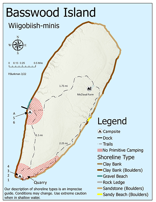
Basswood Island

Wiigobiish-minis

Follow the longer loop through an abandoned farm landscape and old brownstone quarry, with a campsite path branching from the dock clearing.

Ranger's note: The 5.5-mile loop is not a measure of how far your campsite is from a boat landing. NPS says sites A, 5 and 6 are on the short branch from the dock-area trail intersection.

DOCK → TRAIL → CAMPSITE

Follow the evidence, not a guessed route

Choose a documented sequence to see how the NPS describes a particular dock, trail and campsite. These are planning steps, not navigational track lines or current travel approval.

NPS trail branchBasswood: dock-side campsites A, 5 and 6Sites: A, 5, 6

Documented relationship: Short right branch at dock clearing

  1. 1

    Verify the west dock and carry gear uphill to the clearing.

  2. 2

    At the island trail junction follow the NPS-described short right-hand branch through group A toward sites 5 and 6.

  3. 3

    Confirm the assigned site and separate return transport.

Before you rely on it: NPS locates the group site roughly 200 yards south of dock; this is a short campsite branch, not the full 5.5-mile farm-and-quarry loop.

NPS day trailBasswood: farm and quarry loopNo campsite claimed

Documented relationship: Farm and Quarry Loop · 5.5 miles

  1. 1

    Confirm west dock and a realistic return vessel plan.

  2. 2

    Start at the clearing uphill from dock and follow the NPS trail loop by the historic farm and brownstone quarry.

  3. 3

    Return to dock via the marked loop and verify conditions before setting out.

Before you rely on it: NPS describes sites 1–4 southwest of the quarry but does not establish a precise branch from the loop to each campsite. This is not a campsite-access line.

Official National Park Service map of Basswood Island showing mapped trails, shoreline types and island landmarks

Original NPS map. Trail lines belong to this source map; our campsite dots are separate published reference coordinates. Enlarge NPS trail map ↗

Trails on the NPS map

  • Farm & Quarry Loop5.5 mi

    NPS route through McCloud-Brigham farm landscape and brownstone quarry.

Read original NPS hiking descriptions ↗

Sites NPS publishes coordinates for 7

Select an individual site to locate the published reference position on the adjacent map. These coordinates do not establish an open campsite, correct access path or available reservation.

OFFICIAL NPS ISLAND MAP

Devils Island

Maji-manidoo-minis

The NPS map tells the history of a light station and its paths, but it is not an invitation to land at the closed south marina.

Ranger's note: South dock/marina and campsites are closed in the reviewed 2026 NPS construction information. The NPS campsite table repeats an anomalous Cat Island coordinate for Devils; do not plot it or interpret it as a valid campsite location.

DOCK → TRAIL → CAMPSITE

Follow the evidence, not a guessed route

Choose a documented sequence to see how the NPS describes a particular dock, trail and campsite. These are planning steps, not navigational track lines or current travel approval.

Closed / no landingDevils: closed south harborNo landing or campsites

Documented relationship: Historical trail descriptions only

  1. 1

    Do not plan a dock landing or an overnight stay at the south marina from the historical NPS map.

  2. 2

    Read the current NPS construction and park conditions notices.

  3. 3

    Choose another island if you need a permitted landing, overnight stay, or campsite.

Before you rely on it: Closed in the reviewed NPS construction record; this guide does not infer a reopening or recommend alternate rock landings.

Official National Park Service map of Devils Island showing mapped trails, shoreline types and island landmarks

Original NPS map. Trail lines belong to this source map; our campsite dots are separate published reference coordinates. Enlarge NPS trail map ↗

Trails on the NPS map

  • East Landing Trail0.13 mi

    Historical link to a natural rock landing; not a recommended landing approach.

  • West Landing Trail0.4 mi

    Historical light-station path; not a current access plan.

  • Boathouse Trail1.0 mi

    Historic trail from the light station to the closed south harbor.

Read original NPS hiking descriptions ↗
No campsite coordinates shown.

Closed marina and campsite access. The published Devils campsite coordinate is anomalous and excluded.

Turn a map into a real trip. Choose a documented public dock, then verify the trail connection, NPS campsite permit and independent return boat plan. A pin alone is not an arrival plan.

Find the island's documented docks ↓Build an island trip brief ↓

LAND HERE? WALK WHERE? SLEEP NEARBY?

From public dock to island trail

Dock names tell you where an island visit may begin. From there, the trails and campsite connections matter just as much. This field desk pairs the NPS public-dock table with its island hiking and campsite directories. It does not route boats or authorize landings.

Not a navigation chart. NPS water-depth figures describe its published typical dock ranges, not present water levels or guaranteed vessel clearance. Docks are first-come, conditions vary, and the Devils Island south landing is closed in the reviewed record. No GPS arrival points or guessed crossing times are provided. Read the NPS dock guidance ↗

Showing 11 documented landing records, including one closed landing. No current berth availability has been checked.

01

Stockton Island · Beach & accessible camping

Presque Isle, west dock

NPS dock listing

6–7 ft · NPS published depth range Historic reference only; actual clearance varies.

Walk from here

Julian Bay Trail (0.4 mi) and Anderson Point Trail (1.4 mi). From the Presque Isle ranger-station area, the short Julian Bay Trail crosses to the beach. Anderson Point takes a longer wooded route between the beach and Presque Isle.

Camping connection

NPS identifies a boardwalk from the west dock to accessible designated campsite #1.

Check before choosing

The Presque Isle–Quarry Bay corridor has an earlier bridge washout alert. Confirm specific trail conditions before choosing a longer walk.

02

Stockton Island · Short hike & forest crossing

Presque Isle, east dock

NPS dock listing

4–7 ft · NPS published depth range Historic reference only; actual clearance varies.

Walk from here

Julian Bay Trail (0.4 mi) and Quarry Bay Trail (3.6 mi). Start from the Presque Isle visitor area for Julian Bay beach. The 3.6-mile Quarry Bay route crosses interior ground and an area where a meadow path may be difficult to follow.

Camping connection

The NPS lists multiple designated Presque Isle campsites; the separately specified accessible site #1 boardwalk starts at the west dock, not necessarily this east dock.

Check before choosing

This shore is not proof that the Quarry Bay trail bridge is repaired or that a vessel has a berth.

03

Stockton Island · Quarry history & group camping

Quarry Bay dock

NPS dock listing

5–6 ft · NPS published depth range Historic reference only; actual clearance varies.

Walk from here

Quarry Trail (1.5 mi) and Quarry Bay Trail (3.6 mi). Walk the shore toward the old Ashland Brownstone Company quarry, or use the longer connection back toward Presque Isle only after checking current trail conditions.

Camping connection

NPS lists accessible group sites A and B with boardwalk access from the Quarry Bay dock.

Check before choosing

Quarry Bay group sites require separate permits and a verified return; the past bridge washout may affect walking to Presque Isle.

04

Oak Island · Long hike & overlooks

West dock

NPS dock listing

4–5 ft · NPS published depth range Historic reference only; actual clearance varies.

Walk from here

Loop Trail (5.2 mi) and Overlook Trail (1.8 mi). From the dock, reach the loop network. NPS places the main overlook about 3.5 miles from the dock, not just the 1.8-mile length of its spur.

Camping connection

Oak has designated individual and group sites, but not every sandspit campsite is at the west dock; match campsite location to your boat plan.

Check before choosing

The reviewed operator listed an Oak overnight shuttle, not a regular same-day hike-and-return service.

05

Sand Island · Lighthouse & boardwalk camp

East Bay dock

NPS dock listing

2–3 ft · NPS published depth range Historic reference only; actual clearance varies.

Walk from here

Lighthouse Trail (2.0 mi) and Wellisch Cabin Trail (0.6 mi). Walk north on the lighthouse path or south along the old cabin road. NPS warns lighthouse boardwalks can be slippery when wet.

Camping connection

NPS identifies accessible campsite #3 and accessible group site C by boardwalk from East Bay dock; the agency is correcting older Sand campsite coordinates.

Check before choosing

There is no maintained route from East Bay to Lighthouse Bay campsites 4 and 5. Old coordinates and private docks must not be treated as access instructions.

06

Raspberry Island · Lighthouse day visit

Light station, west dock

NPS dock listing

5–6 ft · NPS published depth range Historic reference only; actual clearance varies.

Walk from here

West Bay Trail (1.0 mi) and Sandspit Trail (0.75 mi). From the lighthouse grounds, reach a west-bay viewpoint or continue through old forest to the southeast sandspit beach.

Camping connection

No designated Raspberry Island campsites and no primitive camping zone. Plan only a day visit.

Check before choosing

Confirm whether an advertised lighthouse tour includes landing and lighthouse access for your actual departure.

07

Raspberry Island · Light station & forest

Light station, east dock

NPS dock listing

3–4 ft · NPS published depth range Historic reference only; actual clearance varies.

Walk from here

West Bay Trail (1.0 mi) and Sandspit Trail (0.75 mi). Use the light-station trail network for shoreline and historic interpretation. Island tour timing depends on the operator.

Camping connection

No designated campsites on Raspberry Island. This is not a camping itinerary.

Check before choosing

Both east and west docks are in the NPS inventory, but neither is a guaranteed public berth or proof of a guided tour.

08

Michigan Island · Lighthouses & lagoon

Light station dock

NPS dock listing

3–5 ft · NPS published depth range Historic reference only; actual clearance varies.

Walk from here

Sandspit / Campsite Trail (1.0 mi) and Lagoon Trail (0.5 mi). The light-station route leads toward the sandspit. NPS describes the lagoon trail as appearing to stop at a bog and resuming beyond it.

Camping connection

Designated Michigan Island campsite #1 is in the NPS directory, but a permit does not include a tour landing or boat pickup.

Check before choosing

A sightseeing cruise that passes a lighthouse is not necessarily a stop ashore. Confirm with the operator.

09

Rocky Island · Quiet trails & campsites

East dock

NPS dock listing

6–7 ft · NPS published depth range Historic reference only; actual clearance varies.

Walk from here

North Trail (0.45 mi), South Trail (0.9 mi), West Trail (1.0 mi). From the bulletin board by the public dock, go north past campsites 4, 5 and A or south along the shore.

Camping connection

The NPS campsite directory includes designated Rocky sites and group site A; confirm site allocation and permit separately.

Check before choosing

Privately occupied land north of Group Site A is not open to visitors.

10

Basswood Island · Quarry heritage loop

West dock

NPS dock listing

2–4 ft · NPS published depth range Historic reference only; actual clearance varies.

Walk from here

Farm and Quarry Loop (5.5 mi). A loop from the dock area passes the historic McCloud-Brigham farm landscape and brownstone quarry. NPS places campsites A, 5 and 6 off the near-dock branch.

Camping connection

Campsites 1–4 are southwest of the historic quarry; group site A and sites 5–6 are reached by a separate short branch near dock clearing.

Check before choosing

The 5.5-mile route is a significant hike, not an arrival-to-campsite distance or a promise of return time.

11

Devils Island · Dock closed — no landing

South landing / marina

Closed landing

No public approach

Walk from here

Historic Boathouse Trail (1.0 mi) — access blocked. NPS lists the historic trail as an island feature, but the south dock and marina closure means this is NOT a visitor landing or hike recommendation.

Camping connection

Campsites remain marked closed in the researched NPS construction/alert record. No primitive camping is allowed.

Check before choosing

Do not land here, treat the historic dock entry as a public berth, or infer reopening from the existence of trail descriptions.

Start with the shore, not an island pin

Get road directions to the Bayfield waterfront or the Little Sand Bay visitor area, then use NPS boating guidance and your operator for the water crossing. These are shore-based orientation links, not recommended boat tracks.

Research snapshot: October 28, 2026. These 11 entries cover the eight islands in this guide, not all 21 islands or every natural beach landing. Sand Island campsite coordinates are being corrected by NPS. All landings, trails, private-property boundaries and transport require checking for your travel date.

THE SOURCE DESK · DATED RESEARCH

What is verified, and what needs a fresh check?

These links tell you where to verify a plan. They are not a live feed of dock openings, available seats or safe boating conditions. Each review date is an editorial snapshot, not the date an NPS or operator webpage was last updated.

Research reviewed October 27, 20262027 service has not been verified

Park conditions & warnings

Conditions and closures can change without this page updating. The NPS alert panel may load dynamically; no absence of alerts is inferred from an empty response.

Review by Nov 3 · official check requiredCheck NPS conditions ↗

Devils Island dock & Little Sand Bay

NPS reported Devils Island marina rehabilitation in progress and continued dock closure during 2026. Do not infer that construction has finished or a landing has reopened.

Review by Nov 3 · verify closureNPS construction ↗

Stockton & Oak island shuttles

Published season: June 20–August 30 in the reviewed 2026 listing. Stockton day or overnight and Oak overnight were the documented products. The page does not verify next season's dates or tickets.

Archived 2026 operator listingCheck operator departures ↗

Lighthouse tour landings

Raspberry and Michigan Island tours were listed by the concessioner. A tour listing is not confirmation of landing access, a particular departure, or a 2027 itinerary.

Archived 2026 tour listingsCheck actual tour ↗

Camping permits, fees & rules

The 30-day individual booking window, group lottery and printed-permit requirements were checked on October 27. Rates and permit systems may change by season.

Reviewed Oct 27 · recheck before bookingNPS permits ↗

Marine weather & sea cave conditions

We do not cache or judge weather here. Read the marine zone forecast for your actual route, then use your captain's or outfitter's judgment. A forecast never guarantees a safe crossing.

Check again before each tripNPS regional marine zones ↗

Source desk last editorial review: . This is not a real-time NPS or ticketing integration. Any automated source-change check creates a review task; it does not mark landings open or publish schedules.

MAKE AN ISLAND PLAN THAT HOLDS UP

Before you leave Bayfield

You've found an island worth visiting. Now work through the three things that decide whether a trip can be planned: how you cross, how you return, and whether the campsite or dock can be used.

This is a logistics screen, not a live booking engine, navigation chart, wave forecast or launch-safety rating. Seasonal operator information was reviewed in October 2026; future seasons require fresh confirmation.

Build your trip brief

No NPS dock-to-trail sequence selected.

No specific island dock selected. A named public dock does not confirm landing or available berth.

YOUR LOGISTICS BRIEF

Plan requires verification

Stockton Island, without assumptions

A published 2026 seasonal shuttle does not prove tickets are available for a future trip. Reserve both directions separately and check the island dock, NPS alerts and marine weather.

Choose a date to see the permit-booking window. No date is assumed.

Your booking sequence

  1. Confirm a permitted departure and return with the authorized island shuttle or an NPS-listed water taxi.
  2. Check the NPS park conditions and the exact island landing.
  3. For overnight visits, obtain your NPS camping permit separately from boat tickets.
  4. Consult NWS marine forecasts and your operator immediately before traveling. Expect weather delays.

NPS currently lists individual campsites at $15 per night, group sites at $30 per night, plus a $10 trip reservation fee. These are historical published rates, not a live checkout quote; transport is separate.

Park rules that change the plan: NPS requires camping permits, and its ordinary individual-site booking window opens within 30 days of arrival. Group camping for 8–21 people follows a separate annual lottery process. An email confirmation is not your actual camping permit: the NPS says to print the permit within seven days of arrival or pick it up at the Bayfield Visitor Center. No campsite permit includes island transportation. Read NPS reservation requirements ↗

THE FIELD GUIDE

Nine ways to meet the islands

The best choice depends on your appetite for water, weather and logistics.

Guided kayaking group with sea kayaks at Meyers Beach
Photo: National Park Service · Public domain
On foot · Explore from dry land

Meyers Beach & the Lakeshore Trail

The sandstone coast has a quieter side above the waves. The rugged Lakeshore Trail reaches overlooks of the mainland caves about 2.5 miles one way from Meyers Beach. Expect roots, stream crossings, steep terrain and a return hike.

Make the most of it: Follow the trail rather than approaching cliff edges. Budget half a day or longer for the sea-cave overlooks.

Access notes: Park at 90500 Meyers Beach Road. NPS lists $5 day parking under 20 feet, $8 for longer vehicles, and a 45-foot maximum vehicle length. Check construction access.
Sea kayaking · Go with expertise

Mainland sea caves by kayak

Water moves through the red-rock chambers, rebounds from the cliffs and can build confused waves. This can be a remarkable guided trip, but it is not a casual paddle on an inland lake.

Make the most of it: For first-time visitors, book an NPS-authorized guided sea-kayak trip. A regional forecast does not prove that the caves are safe.

Access notes: NPS recommends a decked sea kayak at least 16 feet long with sealed bulkheads, PFD, spray skirt, cold-water protection and rescue skills. It discourages sit-on-top and open kayaks, canoes and paddleboards.
Cruises · An easy introduction

Narrated Grand Tour

A narrated sightseeing boat follows the island landscape from Bayfield. A cruise is ideal for those who want to see offshore cliffs, lighthouses and distant caves without planning their own boat passage.

Make the most of it: Choose this for a first visit or a mixed-age group; plan an island landing separately if you want to explore on foot.

Access notes: Operator describes a typical 2.5–3.25 hour cruise. Its published daily 2026 tour schedule ended October 18. Route, landing and future availability are not guaranteed.
Island visit · Old stone, wild shore

Sand Island & lighthouse

Forest paths, beaches and the 1881 sandstone lighthouse give Sand Island its own character. Public docking at East Bay exists, but that is not a promise of a vacant dock or landing conditions.

Make the most of it: Choose your authorized excursion or safe private-boating plan before choosing a trail. Verify tour/lighthouse schedules.

Access notes: Water access only. Little Sand Bay has 2026 marina construction with reduced parking and possible access changes.
Raspberry Island Lighthouse overlooking Lake Superior
Photo: National Park Service · Public domain
Lighthouses · Life on the light station

Raspberry Island Lighthouse

The white lighthouse and red roof stand above the lake, preserving the history of the people who kept vessels safe through long Lake Superior nights.

Make the most of it: Look for an authorized lighthouse excursion, and verify whether the outing actually includes a landing and tour.

Access notes: Boat access only; lighthouse openings and island stops vary with schedule and weather.
Island visit · Beaches that ask you to linger

Stockton Island & Julian Bay

Stockton's forests and Julian Bay shoreline make it a strong choice for a longer island day. On these beaches the landscape becomes the destination, not a viewpoint to tick off.

Make the most of it: Arrange a full island outing with time for its trails, or build it into a permitted camping itinerary.

Access notes: No car access. Shuttle schedules, camping permits and marine landing conditions must be verified.
Ferry island · The island with a road

Madeline Island & Big Bay

The car-and-passenger ferry from Bayfield crosses to La Pointe. Big Bay State Park offers a long beach, boardwalks and woodland trails, with more independence than a boat-tour stop.

Make the most of it: A useful full-day option if you want an island experience and the flexibility of road access.

Access notes: Madeline is outside the National Lakeshore. Ferry boarding is generally first come, first served, subject to season and weather; state park fees are separate.
Remote islands · The wild outer edge

Devils Island's sea caves

The northernmost sea caves reveal what the lake can do to sandstone over centuries. They're photogenic, remote and exposed.

Make the most of it: Look for an authorized offshore viewing trip; don't treat it as a novice paddling destination.

Access notes: Devils Island marina is closed during the NPS 2026 rehabilitation project. Water views do not imply permission or safe ability to land.
Backcountry · Stay after the boats depart

Island overnight camping

At night the harbor lights become distant points across the water. Camping brings new rewards, but the logistics of campsite, transport, weather and permits are inseparable.

Make the most of it: Secure campsite reservations and a safe water-transport plan together, with weather flexibility.

Access notes: NPS campsites are tent-only and are not drive-up. Camping permits and fees are required; some mainland sites require hiking or kayaking.

A DIFFERENT SEASON

Winter caves are extraordinary. Access is rare.

Some winters build curtains of ice against the mainland cliffs. The NPS closes the cave zone unless the superintendent formally declares it open. A frozen shoreline or ice map never establishes safe passage.

Official ice-cave rules ↗ · Park ice line: 715-779-3398, option 3

Frozen sandstone sea caves at Meyers Beach in a prior winter
Photo: Jeff the quiet · CC0 1.0

THE LAND BEHIND THE JOURNEY

What carved this place?

The arches and caves come from ancient sandstone worked by waves, wind and winter ice. Rare plants live in moist rock crevices. Wisconsin DNR documents these fragile maritime cliffs; stay on established visitor routes.

The islands also contain unusual forests, lagoons and freshwater systems. The USGS water-resources study and Wisconsin maritime forests inventory explain the ecology beyond the caves.

PART OF YOUR LAKE SUPERIOR CIRCLE TOUR

Give Bayfield more than a quick stop.

A cruise and a night in town may be the perfect introduction. If the mainland caves or an offshore island are your goal, give yourself a weather-flexible day and arrange transport first.

Return to the Circle Tour ↗

Sources, imagery and limitations

Verified October 27, 2026. Sources: NPS visitor planning, NPS kayak safety, NPS fees, NPS construction, UW Sea Caves Watch, cruise operator, ferry operator. Historical images do not depict current conditions. Map markers are geographic reference points only.