Chris Izworski Waterways

A waterway field guide / Ottawa to Kingston

The Rideau Canal in your own time.

From Ottawa's stone lock flight to the quiet lakes near Kingston. Choose your own way to explore this historic waterway.

Season check: navigation ended October 12, 2026.Lockstations are closed to the public for the off-season. Do not enter closed grounds. 2027 hours have not been verified.
When can I visit?

Parks Canada reports lockstations are unmaintained from Thanksgiving to Victoria Day. Current operations and future opening dates must be checked before traveling. Check official station notices.

Your visit begins here

How will you experience the canal?

Source-linked visitor choices. Official operating conditions are checked separately.

Start with a historic lockstation. Parks Canada provides each site's location and visitor details. These are orientation links, not guaranteed open entrances, and there is no operating-hours claim for 2027.

  1. Ottawa Locks: eight chambers beneath Parliament Hill. Official profile · View in Google Maps
  2. Merrickville: a three-lock station among the shops and heritage buildings of an old mill village. Official profile · View in Google Maps
  3. Smiths Falls Combined: one large chamber replaced a flight of three in 1974. Official profile · View in Google Maps
  4. Newboro: a historic blockhouse beside a navigational cut through high ground. Official profile · View in Google Maps
  5. Chaffeys: a rural lock and swing bridge in lake country. Official profile · View in Google Maps
  6. Jones Falls: a flight of three lower chambers, an upper chamber and the remarkable Great Stone Arch Dam. Official profile · View in Google Maps
  7. Kingston Mills: a historic lock flight, railway crossing and canal blockhouse. Official profile · View in Google Maps

Published paddling trips: Perth to Beveridges Locks via the Tay Canal (12 km, one day), and Upper Brewers Locks to Newboro (39 km, two days). These are official itinerary distances, not navigation lines; lockstation and route access remain subject to official conditions.

Step inside the engineering

How does a lock lift a boat?

Picture a boat at the foot of the canal. Two pairs of gates make a watertight chamber, and gravity moves water until the boat reaches the next level. Try the five stages below. This is a teaching diagram, not a scale model of a specific lock.

Cutaway of a Rideau-style lift lock A boat moves from lower water at left into a stone chamber, rises as water enters, and exits to higher water at right. Manual steps and text explain gate and valve operation. Lower water Higher water Lock chamber Lower gates Upper gates

Illustrative side view, not to scale. Water changes only when the gates are closed; the simulator does not model real lock dimensions, timing or boat handling.

01 / 05

Enter at the lower water level

The lower gates open when the water inside the chamber matches the water below. A boat enters slowly under the direction of lock staff.

  1. Enter from below
  2. Close both gates
  3. Let the water rise
  4. Open the upper gates
  5. Leave at the new level

Parks Canada explains the real sequence in Locking through safely. Real lock staff control all operations.

A canal in cross-section

Follow the climb, chamber by chamber

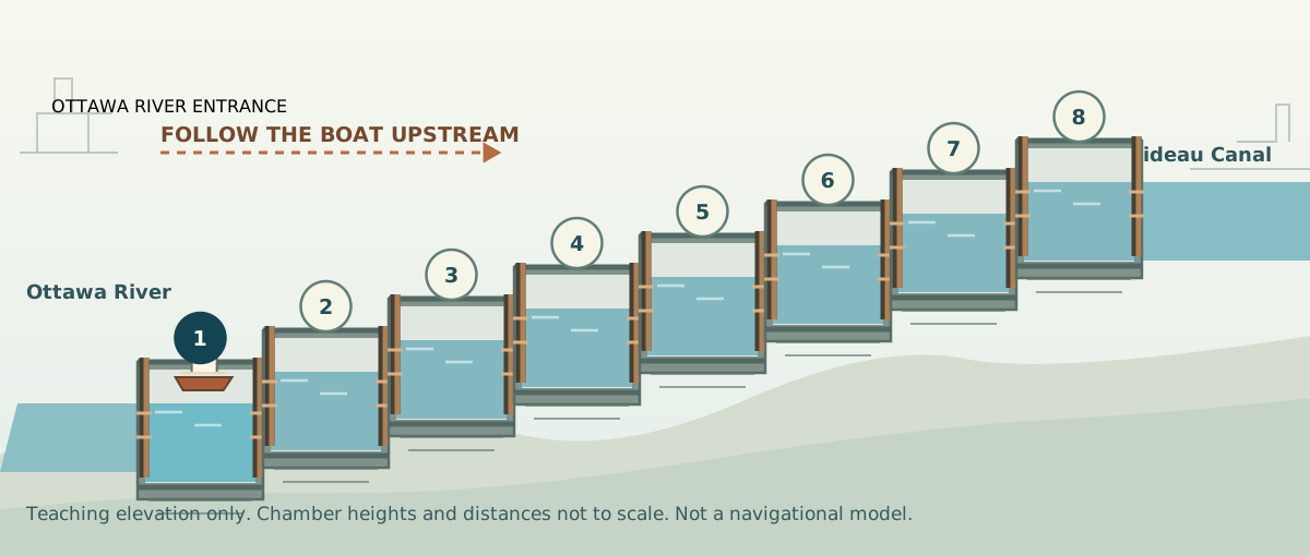
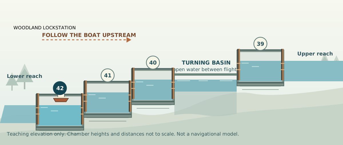
Follow a boat as water carries it uphill, one chamber at a time. Ottawa climbs through eight adjoining locks beneath the city. At Jones Falls, three lower chambers open into a turning basin before a separate upper lock.

Side-elevation drawing with eight numbered, connected Ottawa Locks climbing from the river to the upper canal
Ottawa: Eight adjoining chambers, 24.1 m of combined lift. Parks Canada station profile.
Side-elevation drawing with three lower Jones Falls locks, a turning basin, and detached upper lock
Jones Falls: Three connected lower chambers, a turning basin, and a separate fourth lock. Parks Canada station profile.

Watch it happen

From illustration to the real canal

These are recorded Parks Canada films, not live cameras. A reliable public livestream of the lock chambers has not been verified.

The canal is more than a straight line on a map

Builders used rivers, lakes, excavated cuts, dams and a chain of locks to cross eastern Ontario. Each stone chamber is part of a larger landscape. The tool focuses on understanding that landscape without pretending every visitor is operating a boat.

How many Rideau Canal locks are there?

Parks Canada describes 24 lockstations and 47 locks including the Tay Canal. The operational index shows 26 individually named lock locations, including separate upper and lower sites at Nicholsons and Beveridges. Bridges and Colonel By Island are different kinds of entries, not additional locks. Official station index.

What is a lockstation, and how is it different from a lock?

A lock is a chamber used to raise or lower boats. A lockstation is the place where one or several chambers are operated. At Jones Falls, for example, four locks form one historic lockstation. Jones Falls profile.

Can I use this map to navigate a boat or kayak?

No. Its pins locate official destinations, not a navigable track, depth, obstruction, wave or portage assessment. Use current charts, local conditions and Parks Canada's operational guidance. Parks Canada orientation map.

When does the canal open for the next season?

The last verified 2026 navigation season ended October 12. This preview has not confirmed 2027 dates or live bridge/lock operations. Check Parks Canada's official hours page closer to travel.