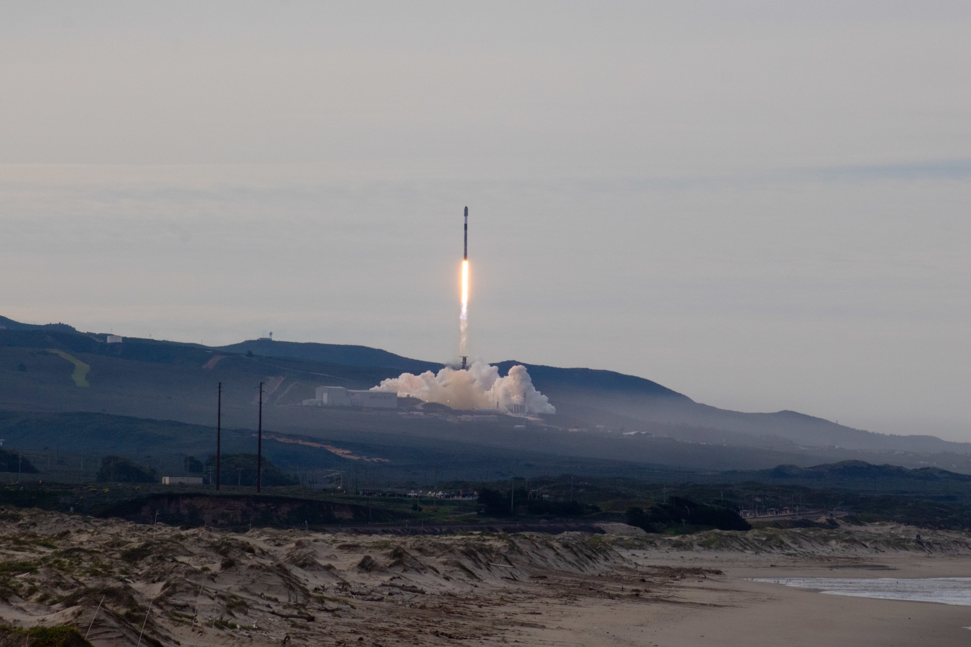
ARCHIVAL PHOTO · Falcon 9 / Starlink 17-20, Jan. 25, 2026 · U.S. Space Force / 2nd Lt. Andrew Taller.
Original photo & credit
CALIFORNIA LAUNCH COUNTRY / LOMPOC
Watch a Vandenberg rocket launch from the California coast
On a clear day, a rocket lifts above the coastal hills and heads over the Pacific. On a foggy day, you might hear the engines before you see a thing. Find six public places around Lompoc, learn what each one offers, and check access for the launch you're chasing.
6 sourced public candidatesAccess-aware planningMission-specific map
THE SHORT ANSWER
For the strongest public launch-viewing prospects, start with Ocean Park, Surf Beach (only when access permits), or Allan Hancock College. Beattie Park, Riverbend Park and Ryon Memorial Park are weaker inland backups when coastal fog or closures rule out the primary choices. You cannot assume access to the military launch pads. The best candidate changes with the mission, daylight, marine-layer clouds, parking, and last-minute launch delays.
Choose a park, beach or campus viewpoint. We'll show where it is, which way the rocket should rise, and the access rules that matter. These are places to investigate, not a map of the rocket's flight.
Coastal access Town parks and campus
MAKE THE MAP YOURS
How do you want to watch?
Compare the six sourced places by your own priority. This is not a live opening report, an official weather forecast, or a predicted rocket flight path.
First place to investigate:Ocean Beach ParkVerify public hours and launch-day restrictions.
The comparison uses fixed public-place profiles, not your location or live visibility.
Lompoc viewing locationsThe interactive map requires JavaScript and a map connection. Every location is described below.
Map reading: Pins mark OpenStreetMap park or station feature centers, not official parking entrances or confirmed access points. No pad locations or rocket flight paths are inferred.
Map data attribution
Choose a pin to see what you can expect from that spot and what to check before you go.
Important: Surf Beach may close for launches and has published public hours of 8 a.m.–6 p.m. Ocean Park closes at sunset. Harris Grade Road, Hawk’s Nest, Marshallia Ranch Road, and Highway 246 are not viewing alternatives. Always verify the actual launch-time access.
A launch from SLC-4E at dusk can be a completely different outing from a morning flight behind the marine layer. Start with the pad and the launch window, then look at the sky.
Start with the actual launch pad: SpaceX uses Space Launch Complex 4 East (SLC-4E) for Falcon launches. SLC-3E is being adapted for United Launch Alliance's Vulcan, while SLC-6 is being developed for future SpaceX operations; neither should be assumed active for a specific mission. The right viewing bearing depends on the verified pad and trajectory, not just the name Vandenberg. Confirm the selected mission in the live planner.
01
With children or a group
Bring the family, not a promise of a pad view.
When the coast is fogged in or off-limits, Beattie, Riverbend and Ryon Memorial parks may offer room to spread out. You could catch the rocket after it clears the hills, but none is a dependable view of the pad; check city park hours and local sightlines.
Allan Hancock College has a locally described partial pad view, though parking rules apply. The live planner provides a bearing from each mapped candidate to the selected launch pad, not a promised sightline.
Ocean Park closes at sunset. Surf Beach lists public hours of 8 a.m. to 6 p.m. and can close for launches. Neither is a dependable after-dark backup simply because a rocket is scheduled.
Use the mission planner to compare the published target with hypothetical delays of 1, 3, or 6 hours. Locations can drop out when daylight or published public hours no longer work.
Start with the coast. Keep inland options in mind.
Ocean Park, Surf Beach and Allan Hancock College are worth looking at first. Inland parks offer a different, usually more distant chance to catch the climb when coast fog or closures get in the way. None is a confirmed launch-day opening.
The first places I'd check
Prioritize these three based on mission timing, legal access and the marine layer. Ocean Park closes at sunset and Surf Beach may close for range operations.
PRIMARY / COAST / LIMITED ACCESS01
Ocean Park
Salt air, a coastal horizon, and a park that closes at sunset.
For launches from SLC-4E, Ocean Park delivers coastal sound and a chance to see the rocket after it clears the horizon. Distance and bearing differ for SLC-3E and SLC-6 missions. It does not provide a direct pad view. Parking is limited and the access road closes when the lot fills.
Access gate: Closes at sunset. A late launch or delay can rule it out.
PRIMARY / COAST / BASE-MANAGED ACCESS02
Surf Beach / Surf Station
Close to the coast and the sound, but launch restrictions come first.
Surf Beach offers a coastal launch experience near Vandenberg. Beach activity, wildlife protections, rail safety and launch operations can change access. A generally open beach is not permission to enter military areas or an active launch safety zone.
Access gate: Published public hours are 8 a.m.–6 p.m.; verify the latest launch-day notice.
PRIMARY / CAMPUS / PARTIAL PAD VIEW03
Allan Hancock College, Lompoc
A partial pad perspective that photographers may appreciate.
Explore Lompoc describes a partial view toward the launch pad, with the rocket visible as it climbs. Campus parking is regulated, especially during class hours, and a published campus location is not a special launch-event access pass.
Access gate: Allan Hancock lists $2 daily permits at the Lompoc Valley Center; recheck prices and enforcement.
Inland alternatives when the shoreline doesn't work
Beattie, Riverbend and Ryon Memorial are less reliable for the initial climb because terrain and distance can obstruct the pad. Consider them only when the coast is inaccessible or low cloud makes an inland sky preferable, and verify each park's hours before travel.
INLAND BACKUP / OPEN LAWNS04
Beattie Park
Picnic lawns and room to wait, with hills between you and the pad.
Open lawns, picnic tables and playground facilities make Beattie a practical place to gather while waiting for a launch. Look for open sky rather than a direct view of the pad; hills and trees may hide the earliest moments.
Access gate: Follow posted city park hours and any event restrictions; nighttime entry is not verified.
INLAND BACKUP / FLEXIBLE FIELDS05
Riverbend Park
A place to spread out, not a front-row pad view.
Riverbend’s fields can be comfortable for groups, but its sports facilities also attract crowds and fill parking. You cannot see the pad directly from the park; the rocket may appear only once it rises over the landscape.
Access gate: Parking and field availability change with sports events; current launch-night hours are unverified.
INLAND BACKUP / DOWNTOWN06
Ryon Memorial Park
A downtown park where waiting for liftoff can be part of the day.
Ryon Park trades a close coastal approach for open lawns, picnic space and proximity to downtown Lompoc. Choose a clear patch of sky and allow for the rocket to clear distant terrain before it appears.
Access gate: Verify park hours, signs and local restrictions; no individual launch opening is confirmed.
Place descriptions reflect Explore Lompoc’s launch-viewing guide and the named land manager. The live tool adds surveyed map feature centers, pad bearings and two nearby NWS forecast reference points. Map centers are not certified entry gates.
03 / Know before you go
Don't chase the rocket onto a closed road.
Older trip guides still mention the top of Harris Grade Road, Hawk’s Nest, Marshallia Ranch Road and Highway 246. Explore Lompoc currently lists these places as closed to public launch viewing. Do not treat an old map pin, roadside shoulder or social post as authorization to park or enter.
Fog can sit against the Vandenberg shoreline while Lompoc enjoys sunshine. That can mean hearing the rocket climb before it breaks into view above the clouds.
WHY PEOPLE TRAVEL / THE TWILIGHT PLUMEThe glowing “space jellyfish” can fill the sky.
Shortly after sunset or before sunrise, the ground may be dark while sunlight still lights a rocket's exhaust high above the atmosphere. The expanding plume can look like a luminous jellyfish and may be visible across Southern California on a clear evening. It is a special twilight lighting effect, not a guaranteed sight at every night launch: the time, trajectory, altitude and cloud cover all matter. A spectacular plume does not override Surf Beach or Ocean Park closing times. NASA: illuminated rocket plume.
CLOUDS
The cloud percentage won't tell the whole story.
The NWS forecast describes total sky cover at a grid location. It does not establish how high the coastal clouds are or whether you will see the rocket’s initial climb.
DAYLIGHT
Twilight plumes can be spectacular. Parks still close.
A launch after sunset may show a bright plume high in the sky. It does not keep Ocean Park or Surf Beach open later, and a scheduled time can move by hours.
MISSION
Check where this rocket actually starts.
Our planner uses the selected mission’s recorded pad coordinate when verifiable. Its compass bearing points toward the pad, not along a verified rocket trajectory or clear terrain viewshed.
Don't guess from a weather icon.
Compare Lompoc and Surf Beach vicinity NWS references for the published mission time, and test what happens when a launch slips.
Look at both forecast reference points. Recheck the operator before departure and before committing to a parking area. If a launch slips into the evening, coastal candidates may no longer be usable.
06 / What visitors ask
What you should know before launch day.
Practical answers, without pretending that tomorrow’s launch or public access is guaranteed.
Where can I watch a Vandenberg rocket launch?
Publicly listed candidates around Lompoc include Ocean Park, Surf Beach when permitted, Allan Hancock College, Beattie Park, Riverbend Park and Ryon Memorial Park. Viewing quality varies by launch pad, weather, terrain, and launch-day access rules.
Can the public enter Vandenberg Space Force Base to watch a launch?
The launch complex is an active military installation, not a general public launch-viewing entrance. Use a documented public location outside restricted areas and check the base's official notices.
Is Surf Beach open for night rocket launches?
The Vandenberg Space Force Base environmental page lists Surf Beach public hours as 8 a.m. to 6 p.m. daily. A night launch does not extend those hours. The beach can also close for operations or conservation restrictions.
Can I watch from Ocean Park after sunset?
No. Explore Lompoc says Ocean Park closes at sunset. Its lot is small and the road may close when parking fills, so it is a poor choice for late-evening missions or delays pushing liftoff near dusk.
Is Harris Grade Road a recommended rocket-viewing spot?
Not currently. Explore Lompoc lists the top of Harris Grade Road, Hawk's Nest, Marshallia Ranch Road and Highway 246 as closed to public launch viewing. Do not use outdated viewing guides as proof of access.
Why does a cloud forecast not guarantee I will see the launch?
A nearby ground-level cloud-cover forecast does not measure marine-layer height, the rocket's actual flight path, or hills blocking the view. The live planner labels the locations of its NWS forecast samples and withholds claims it cannot establish.
Where do I find the next Vandenberg launch time?
Open Rocket Launch Live USA with California selected. It displays the selected mission, the precision and age of its schedule source, NWS reference forecasts when the launch target is sufficiently precise, and hypothetical delay comparisons. Always recheck the launch operator and range before travel.
ONE LAST CHECK
Find your rocket. Choose your horizon.
Six public locations, a real mission record, documented access limits, nearby NWS reference forecasts, and hypothetical delay scenarios. The viewing map updates with the selected Vandenberg mission.
Researched November 3, 2026. This is a visitor field guide, not an official notice, live beach-opening report or guaranteed view. Vandenberg Space Force Base and the land managers control closures and access; launch operators control missions. The photo depicts a past launch, not an upcoming flight. No U.S. Space Force endorsement is implied.