Skip to frozen Michigan places
Chris Izworski

Frozen Michigan · A Winter Shoreline & Waterfall Field Guide by Chris Izworski

Where Michigan turns to blue ice, amber mist, and sculpted stone.

Every winter, groundwater seeping through porous Cambrian sandstone freezes into 40-foot blue curtains behind Munising, tannin-amber water thunders inside snowy ice collars at Tahquamenon, and Lake Michigan gales encase red pierhead lighthouses in tons of frozen spray. Here are 11 extraordinary places to witness frozen Michigan from solid ground—along with the geology of how they form and how I plan a safe winter visit.

Explore the 11 winter ice stops

By Chris Izworski · 11 land-based winter ice & waterfall viewpoints · Official NPS & Michigan DNR winter access notes

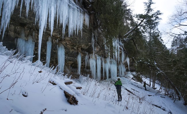
Tall blue and white ice curtains at Pictured Rocks inland cliffs in winter
Photo: National Park Service · NPS Public Domain · Pictured Rocks inland sandstone ice curtains
Close view of Bond Falls winter ice and frozen spray
Photo: Stefan.Anderson · CC BY-SA 4.0 · Bond Falls on the Middle Branch Ontonagon River
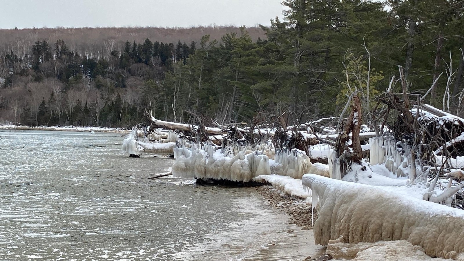
Ice encrusted driftwood at Sand Point beach on Lake Superior
Photo: National Park Service · NPS Public Domain · Ice-glazed driftwood on Sand Point Beach, Munising
01 · Sandstone Ice CurtainsWhere groundwater seeps from cliff faces and freezes drop by drop
02 · Frozen WaterfallsWhere cedar-swamp rivers carve through snow-draped gorges and rim ice
03 · Shoreline Ice SculpturesWhere winter gales coat lighthouses, piers, and driftwood in frozen spray

No lake ice is certified safe by this guide. Stay on shore and check official notices before visiting.

Heads-Up Before You Drive to Munising · Official NPS Notice

Munising Falls Trail is closed until further notice.

If you've visited Munising in past winters, you probably remember walking the short paved canyon trail to Munising Falls. The April 2025 washout damaged that corridor. A September 2026 repair announcement estimated completion by late 2027, weather permitting; check the NPS closure notice before planning a visit. Skip the Munising Falls lot this winter and head two minutes down the road to Sand Point instead, where the inland sandstone ice curtains and Lake Superior beach remain open. Read the NPS reconstruction update ↗

Check NPS Munising Falls status ↗

Frozen Michigan · field desk

Where can I see winter ice without stepping onto it?

Choose the scene you came for. Shortlist real, land-based viewpoints with winter access cautions, source links and the right checks before you travel.

Planning ideas, not an all-clear. Lake-wide ice cover is not a bay percentage or a safe-ice test. Cold air cannot confirm an ice curtain. Published winter road guidance is not proof of parking or trail access today.

Current formation is unconfirmed until a dated official observation supports it. Check the land manager before traveling.

Begin with Sand Point Beach for Lake Superior ice sculptures, or consider Grand Haven and St. Joseph from shore. These are possible viewpoints, not promises that ice is formed today.

Following freeze-up on Saginaw Bay?

This is a separate question from ice caves or waterfalls. Open the Saginaw Bay tracker for dated regional weather and wind hazards, and inspect NOAA Great Lakes ice charts. Whole-Lake Huron coverage does not tell you Saginaw Bay ice concentration, thickness, or travel safety. Michigan DNR ice safety.

Five-site ice formation evidence desk · Upper Peninsula waterfall guide · Winter weekend alternatives · Current Pictured Rocks closures

How the Landscape Freezes

Three completely different ways Michigan builds winter ice

When you understand how groundwater seepage, river mist, and wind-driven wave spray behave in sub-freezing air, you know what to look for in the field—and why each formation demands its own respect.

FIELD LESSON 01 · SANDSTONE SEEPAGE

Why Pictured Rocks and Eben weep blue and amber ice

Even when air temperatures plunge below zero, groundwater inside the porous Munising and Jacobsville sandstone stays above freezing until the moment it hits the cliff face. Drop by drop, that slow seepage freezes into 30-to-50-foot vertical columns—tinted pale blue by trapped air or golden-tan by iron and forest tannins.

Field rule: Multi-ton ice columns can detach from warm rock without warning during a sunny afternoon or thaw—admire them from the trail, never directly underneath an overhang.

The 11 Winter Stops

Find your kind of winter ice.

Filter by formation type, peninsula, how steep the walk in feels, or how the winter parking lot is maintained.

Showing all 11 frozen Michigan stops with winter approach notes and official park links.

Tall blue and white ice curtains at Pictured Rocks inland cliffs in winter
Photo: National Park Service · NPS Public Domain · Pictured Rocks inland sandstone ice curtains

Munising · Pictured Rocks National Lakeshore · Moderate Walk

Sand Point Inland Ice Curtains

NPS Sand Point Road · Unmaintained uphill approach

You don't have to cross frozen Lake Superior to stand in front of Pictured Rocks' famous winter ice curtains. Along the inland sandstone escarpment just behind Sand Point Road, mineral-rich groundwater seeps out of the porous bluff all winter and freezes into 30-to-40-foot columns of pale blue, white, and iron-stained gold.

The curtains usually begin building in mid-December and hold into late March or early April, thickening after every freeze-thaw cycle.

How I walk inUse the Sand Point Beach lot if open, walk back about a quarter to a half mile along the road and look for NPS viewing-area signs. There is no designated uphill trail; check current road access and closures before the drive.

Good to know: Never park on the shoulder of Sand Point Road—the plow berms leave zero room and rangers ticket or tow cars that block the lane. Pack microspikes or ice cleats for the uphill climb, and leave dogs in town (pets aren't allowed at the ice formations).

Ice encrusted driftwood at Sand Point beach on Lake Superior
Photo: National Park Service · NPS Public Domain · Glazed driftwood on Sand Point Beach

Munising · Lake Superior Shoreline · Easy Walk

Sand Point's Ice-Sculpted Shore

Plowed NPS beach lot · Drive-up shoreline access

Before or after you hike up to the inland cliff curtains, walk fifty yards out to the shoreline at Sand Point Beach. In early and mid-winter, northwest rollers off Lake Superior throw freezing spray across the bleached driftwood logs and beach cobbles, encasing every branch in smooth, translucent armor while pancake ice jostles in the bay.

Sand Point is the only Lake Superior beach inside Pictured Rocks National Lakeshore that stays plowed for standard passenger cars all winter.

How I visitPull right into the Sand Point Beach turnaround lot at the end of Sand Point Road and walk the dry landward edge of the beach with a camera and windproof shell.

Good to know: Stay on the true sand beach and never walk out onto shoreline ice volcanoes or wave-built ice shelves—they look like solid ground after a snowfall, but they overhang open, freezing Lake Superior surf underneath.

Historic wooden East Channel Lighthouse on Grand Island across from Munising Bay, October 2007
Photo: James Phelps · CC BY 2.0 · Historic East Channel Lighthouse across the channel from Sand Point

Sand Point Overlook · Munising Bay · Easy Glassing Stop

Grand Island's Cliffs & Channel from Shore

Viewed safely from Sand Point Beach · Bring binoculars

Directly across the East Channel from Sand Point Beach rise the sandstone cliffs of Grand Island National Recreation Area. On crisp, clear winter mornings, the low sun lights up the island's distant ice columns across the water—giving you a sweeping two-shoreline perspective without ever stepping onto unstable bay ice.

Because the narrows between Sand Point and Grand Island funnels invisible underwater currents, the National Park Service recommends viewing Grand Island's winter cliffs through binoculars from the mainland beach.

How I glass the channelPack 8x or 10x binoculars (or a 200mm+ telephoto lens) in your daypack while you're already parked at Sand Point Beach and scan the opposite bluff line when the morning sun hits the rock.

Good to know: Even when Munising Bay looks completely white from shore, Lake Superior currents thin the ice from underneath in the East Channel. Enjoy the view from the mainland beach.

Ice columns at Eben Ice Caves photographed in March 2012
Photo: ThePenultimateOne · CC BY-SA 4.0 · Hanging ice columns at the Eben Ice Caves

Eben Junction · Rock River Canyon Wilderness · Demanding Hike

Eben Ice Caves (Rock River Canyon)

Seasonal private-field trailhead · Microspikes essential

Tucked inside the Hiawatha National Forest's Rock River Canyon Wilderness between Marquette and Munising, the Eben Ice Caves aren't true bedrock caverns—they are a massive wall of frozen seepage cascading over a recessed sandstone overhang, creating a glowing chamber of translucent yellow and blue ice pillars you can walk beside.

The roughly 1.5-mile round-trip hike crosses a wind-swept private farm field on Frey Road (whose owners graciously allow winter hikers to park and cross) before dropping down steep, slick ravines in the woods.

How I prepare for the hikeDo not attempt Eben in smooth-soled winter boots. Put steel-tooth microspikes or crampons on before you leave the tree line—hundreds of boots polish the ravine slopes into an icy chute by January.

Good to know: Because access crosses private farmland before entering the wilderness area, respect all posted parking markers on Frey Road, pack out every scrap of trash, and stay alert for falling icicles during mid-day thaws.

Upper Tahquamenon Falls with winter snow and river ice in January 2004
Photo: James Phelps · CC BY 2.0 · Upper Tahquamenon Falls in January

Paradise · Tahquamenon Falls State Park · Moderate Walk

Upper Tahquamenon Falls

Plowed state park lot · Maintained winter path to brink

If you only make one winter trip to the eastern Upper Peninsula, make it Upper Tahquamenon Falls after a January lake-effect blitz. Nearly 200 feet wide and dropping 50 feet into a snow-lined gorge, the river's cedar-and-hemlock tannins glow like dark root beer against three-foot pillows of pure white snow and turquoise rim ice.

Even in the deepest sub-zero cold snaps, the sheer volume of the Tahquamenon River keeps the center chute thundering while freezing mist builds massive ice bells along both flanks.

How I visit in winterPark in the plowed Upper Falls day-use lot off M-123, check the chalkboard at the trailhead for daily snow depths and lantern-lit snowshoe dates, and walk the packed forest path out to the upper viewing area.

Good to know: Some of the long wooden staircases down into the gorge ice over completely and are gated off for winter safety—stick to the open upper overlooks and wear traction cleats on packed snow.

Lower Tahquamenon Falls cascades surrounded by leafy forest in August 2020, not a winter conditions photograph
Photo: Joe Passe · CC BY-SA 2.0 · Lower Tahquamenon Falls island cascades, August 2020 · summer reference, not winter conditions

Paradise · Tahquamenon Falls State Park · ~1-Mile Winter Walk

Lower Tahquamenon Falls

DNR winter route mapped · Confirm current plowing

Four miles downstream from the roaring Upper Falls, the Tahquamenon splits around a forested island in a series of five smaller, terraced ledges. In winter, with the summer crowds gone and snow weighting every cedar bough along the bank, the Lower Falls feels wonderfully quiet and intimate.

Winter access differs from summer. The Michigan DNR maps a winter walking route near Hemlock Campground, but the actual parking and approach need checking before you set out.

How I walk inCheck the DNR winter trail map and current park plowing notices first. A mapped winter route approaches the Lower Falls, but today’s parking lot and maintenance status are not verified here.

Good to know: Don't plan on hiking the 4-mile River Trail between the Upper and Lower Falls in winter—it isn't groomed, and deep drifts plus icy sidehills make it a tough bushwhack. Drive M-123 between the two entrances instead.

Winter approach: The Lower Falls summer parking loop may be closed to vehicles. Confirm plowed parking and the winter route with the park; the trail to Upper Falls is not maintained in winter.

Layered rock cascades of Wagner Falls near Munising in April 2006, not a winter ice photograph
Photo: Two Hearted River · CC BY-SA 3.0 · Wagner Falls rock tiers near Munising (spring melt reference)

Munising · Wagner Falls Scenic Site · Short Hemlock Walk

Wagner Falls Scenic Site

Small roadside pull-off on M-94 · Check plow berm before stopping

Just south of the M-28/M-94 junction outside Munising, Wagner Creek tumbles over delicate, stair-stepped dolomitic rock shelves inside a cathedral of old-growth hemlock and pine. Because the creek is spring-fed and sheltered in a narrow ravine, it builds intricate lacy ice shelves while dark water keeps threading down the center.

The walk from the M-94 trailhead to the viewing platform is only about a tenth of a mile along the creek, making it a quick, rewarding stop when the small pull-off has been cleared.

How I check itWhen driving into Munising on M-28, swing one mile south on M-94. Only pull in if the small DNR lot is plowed clear—never park on the shoulder of M-94 in snowbank season.

Good to know: The wooden boardwalk along Wagner Creek isn't salted or shoveled in winter, so expect deep snowpack or a packed snow trough that calls for snowshoes or microspikes.

Close view of Bond Falls winter ice and frozen spray
Photo: Stefan.Anderson · CC BY-SA 4.0 · Bond Falls in January ice

Paulding · Western Upper Peninsula · Experienced Winter Trek

Bond Falls Scenic Site

Summer park road unplowed in winter · Backcountry snowshoe approach

Where the Middle Branch of the Ontonagon River spreads 100 feet wide over fractured dark volcanic rock, Bond Falls creates one of the most dramatic winter amphitheaters in the Upper Midwest. Dozens of separate chutes braid between pillows of snow and sculpted spray ice.

In summer you can drive right to the boardwalk, but the DNR only maintains vehicle access from mid-May through mid-October—turning a winter visit into a genuine Western U.P. snowshoe expedition.

How experienced visitors approach itBecause the seasonal park road is gated or shared with snowmobile traffic in winter, confirm current local trailhead parking near Paulding before you go, bring backcountry snowshoes, and never attempt to drive down an unplowed park road.

Good to know: Even the timber boardwalk at the base of the falls disappears under deep Western U.P. drifts in January and February. Give the open river channels a wide berth.

Limestone ledges and flowing water at Ocqueoc Falls in Presque Isle County in April 2013, not a winter ice photograph
Photo: Tony Faiola · CC BY 2.0 · Ocqueoc Falls limestone ledges in Presque Isle County (spring reference)

Millersburg · Presque Isle County · Northern Lower Peninsula

Ocqueoc Falls Bicentennial Pathway

Directly off M-68 · Check day-use lot snow clearance

You don't have to cross the Mackinac Bridge to see a natural rock waterfall in winter. Halfway between Onaway and Rogers City in the northeast Lower Peninsula, the Ocqueoc River drops over a pair of Devonian limestone ledges that build shelves of river ice while dark water swirls through the center chute.

Because the waterfall sits just a short walk from M-68 and connects to the 6-mile Ocqueoc Falls Bicentennial Pathway, it's a favorite quiet winter stop for snowshoers and cross-country skiers in Sunrise Side country.

How I visitCheck the day-use entrance right off M-68 (across from the seasonal state forest campground). Even if the inner loop isn't plowed to bare pavement after a fresh storm, the walk from the entrance to the limestone ledges takes less than five minutes on snowshoes.

Good to know: Limestone shelves coated in river glaze are as slick as greased glass—admire the ledges from the snowy bank rather than stepping out onto the flat rock shelf.

Red Grand Haven lighthouse and winter ice on the Lake Michigan waterfront
Photo: Wayne Silver · CC BY 2.0 · Grand Haven South Pierhead Lights in December ice

Grand Haven State Park · Lake Michigan · Easy Beach View

Grand Haven's Frozen Pierhead Lights

State park beach viewpoint · Never walk the icy pier

After a two-day northwest gale across open Lake Michigan in December or January, the red inner and outer lighthouses on Grand Haven's South Pier transform into something out of the Arctic. Wave after wave explodes against the concrete wall, and the airborne spray freezes instantly onto the catwalk ironwork and lantern towers in bulbous white tiers.

Grand Haven State Park sits right at the foot of the pier, giving photographers a front-row view from solid sand without ever setting foot on the wave-swept concrete.

Where I stand for the photoPark at Grand Haven State Park (check for winter sand-drift closures on the beach road after big storms) and frame the red towers from the dry upper beach or the channel boardwalk.

Good to know: Never walk out onto the concrete pier when it's glazed in ice or when waves are breaking—a single sneaker wave over a rounded ice dome will sweep you straight into Lake Michigan.

St Joseph Michigan lighthouse and pier during a Lake Michigan winter storm in December 2005
Photo: Myron Reynard · CC BY-SA 2.0 · St. Joseph winter storm, December 2005 · archival view, not current conditions

St. Joseph · Southwest Lake Michigan · Easy Park Overlook

St. Joseph's Ice-Encased North Pier Lights

View from Silver Beach or Tiscornia Park · Stay off the piers

Few winter images in the Great Lakes are more famous than the twin North Pier lights at St. Joseph buried under 20 feet of wind-sculpted ice feathers. Because southwest Michigan sits at the end of a long northwest fetch down Lake Michigan, early-winter gales hurl massive spray plumes across the elevated catwalk, turning the outer range light into a leaning white Wedding Cake of ice.

You can photograph the entire spectacle from the safety of Silver Beach County Park (south of the river mouth) or Tiscornia Park (on the north side).

How I photograph itBring a telephoto lens (70–200mm or longer) and shoot from the landward park overlooks at Silver Beach or Tiscornia Park—the compression makes the frozen lighthouse tower loom huge against the gray winter rollers.

Good to know: Berrien County authorities strictly warn visitors to stay off the ice-covered piers. Once spray freezes over the concrete deck, there is no traction and no safe footing near the water.

My Non-Negotiable Winter Shoreline Rule

Admire the ice from solid ground—never use it as a trail.

Every winter in Michigan, people get into trouble by mistaking shore-bound pancake ice, hollow beach ice volcanoes, or spray-coated concrete piers for solid walking surfaces. Satellite ice coverage on my Michigan Ice Tracker shows where surface ice has formed across the lakes—never whether it is thick enough to hold a person. Keep your boots on the sand, the boardwalk, or the forest trail, pack steel microspikes for packed snow, and let a good pair of binoculars or a telephoto lens close the distance.

Michigan DNR Ice Safety Guide ↗ · Pictured Rocks Winter Safety & Rules ↗ · Michigan DNR Park & Trail Closures ↗